![](/images/other/stat-length.png)
![Excursión Senderismo La Chapelle-Janson - GR 34 étape 3 - Photo](https://media.geolcdn.com/t/1900/400/ext.pjpeg?maxdim=2&url=https%3A%2F%2Fservices.sitytrail.com%2FGeolivesWS%2FDownloadMedia.ashx%3FTrailID%3D271004%26Media%3Dfix__20140409154616.jpg)
GR 34 étape 3
lagardienne
Usuario
![Longitud](/images/other/stat-length.png)
Longitud
28 km
![Altitud máxima](https://static1.geolcdn.com/siteimages/upload/files/1508320355ic_sort_altitude_max_24dp.png)
Altitud máxima
192 m
![Desnivel positivo](https://static1.geolcdn.com/siteimages/upload/files/1508320355ic_sort_den_pos_24dp.png)
Desnivel positivo
492 m
![Km-Effort](/images/other/stat-length.png)
Km-Effort
34 km
![Altitud mínima](https://static1.geolcdn.com/siteimages/upload/files/1508320355ic_sort_altitude_min_24dp.png)
Altitud mínima
106 m
![Desnivel negativo](https://static1.geolcdn.com/siteimages/upload/files/1508320355ic_sort_den_neg_24dp.png)
Desnivel negativo
451 m
![Boucle](https://static1.geolcdn.com/siteimages/upload/files/16400158638029165_repeat_loop_refresh_sync_direction_icon.png)
Boucle
No
Fecha de creación :
2014-12-10 00:00:00.0
Última modificación :
2014-12-10 00:00:00.0
![Senderismo](https://static1.geolcdn.com/sitytour/trail-icons/101.png)
6h55
Dificultad : Fácil
![Escanee este código QR para abrir la excursión en la aplicación SityTrail](https://capi.geolives.com/qq0zvz2zws4bq2lad0pu/sitytour/trails/271004/qr.png?size=200)
Aplicación GPS de excursión GRATIS
A propósito
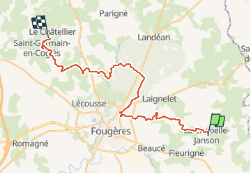
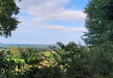
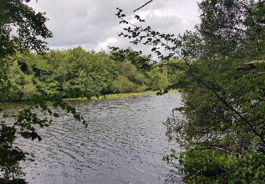
Ruta Senderismo de 28 km a descubrir en Bretaña, Ille-et-Vilaine, La Chapelle-Janson. Esta ruta ha sido propuesta por lagardienne.
Descripción
Bientôt sur le jardindelolo.fr le récit de mon périple sur le GR 34, étape par étape avec commentaires et photos.
Localización
País:
France
Región :
Bretaña
Departamento/provincia :
Ille-et-Vilaine
Municipio :
La Chapelle-Janson
Localidad:
Unknown
Salida:(Dec)
Salida:(UTM)
640774 ; 5356664 (30U) N.
Comentarios
Excursiones cerca
![Excursión A pie Landéan - Les Vieux Châteaux - Photo](https://media.geolcdn.com/t/375/260/122c427c-456b-4f47-979b-0a8d83dc03ab.jpeg&format=jpg&maxdim=2)
![A pie A pie](https://static1.geolcdn.com/sitytour/trail-icons/100.png)
Les Vieux Châteaux
A pie
Fácil
(1)
Landéan,
Bretaña,
Ille-et-Vilaine,
France
![](/images/other/stat-length.png)
5,3 km | 6,3 km-effort
1h 26min
![](https://static1.geolcdn.com/siteimages/upload/files/16400158638029165_repeat_loop_refresh_sync_direction_icon.png)
Sí
![Excursión A pie La Chapelle-Janson - Circuit du Relais des Vallées - Photo](https://media.geolcdn.com/t/375/260/e82b6ec7-9e63-4011-a5de-bee12efb17ab.jpeg&format=jpg&maxdim=2)
![A pie A pie](https://static1.geolcdn.com/sitytour/trail-icons/100.png)
Circuit du Relais des Vallées
A pie
Fácil
La Chapelle-Janson,
Bretaña,
Ille-et-Vilaine,
France
![](/images/other/stat-length.png)
12,8 km | 15,9 km-effort
3h 36min
![](https://static1.geolcdn.com/siteimages/upload/files/16400158638029165_repeat_loop_refresh_sync_direction_icon.png)
Sí
![Excursión Senderismo La Chapelle-Janson - GR_37_AG_21_Chapelle-Janson_Luitre-Dompierre_20210620 - Photo](https://media.geolcdn.com/t/375/260/75f6a612-c345-4abb-801a-f0c14c144f68.jpg&format=jpg&maxdim=2)
![Senderismo Senderismo](https://static1.geolcdn.com/sitytour/trail-icons/101.png)
GR_37_AG_21_Chapelle-Janson_Luitre-Dompierre_20210620
Senderismo
Difícil
La Chapelle-Janson,
Bretaña,
Ille-et-Vilaine,
France
![](/images/other/stat-length.png)
13,1 km | 16,2 km-effort
3h 16min
![](https://static1.geolcdn.com/siteimages/upload/files/16400158638029165_repeat_loop_refresh_sync_direction_icon.png)
No
![Excursión Senderismo Le Loroux - rrr - Photo](https://media.geolcdn.com/t/375/260/b86485e9-1897-4f8a-825a-a3943d239ad2.jpg&format=jpg&maxdim=2)
![Senderismo Senderismo](https://static1.geolcdn.com/sitytour/trail-icons/101.png)
![Excursión Senderismo Landéan - Le chemin des vieux châteaux - Photo](https://media.geolcdn.com/t/375/260/ext.jpg?maxdim=2&url=https%3A%2F%2Fservices.sitytrail.com%2FGeolivesWS%2FDownloadMedia.ashx%3FTrailID%3D1019877%26Media%3Dfix__20180810142706.jpg)
![Senderismo Senderismo](https://static1.geolcdn.com/sitytour/trail-icons/101.png)
Le chemin des vieux châteaux
Senderismo
Muy fácil
Landéan,
Bretaña,
Ille-et-Vilaine,
France
![](/images/other/stat-length.png)
5,5 km | 6,5 km-effort
1h 9min
![](https://static1.geolcdn.com/siteimages/upload/files/16400158638029165_repeat_loop_refresh_sync_direction_icon.png)
Sí
![Excursión Marcha nórdica Landéan - Fougères le 15-03-2019 - Photo](https://media.geolcdn.com/t/375/260/ext.jpg?maxdim=2&url=https%3A%2F%2Fstatic1.geolcdn.com%2Fsiteimages%2Fupload%2Ffiles%2F1545311037marcheuse_200dpi.jpg)
![Marcha nórdica Marcha nórdica](https://static1.geolcdn.com/sitytour/trail-icons/102.png)
Fougères le 15-03-2019
Marcha nórdica
Muy fácil
Landéan,
Bretaña,
Ille-et-Vilaine,
France
![](/images/other/stat-length.png)
7,8 km | 9,4 km-effort
1h 57min
![](https://static1.geolcdn.com/siteimages/upload/files/16400158638029165_repeat_loop_refresh_sync_direction_icon.png)
Sí
![Excursión Senderismo Landéan - Fougères_Père Tacot - Photo](https://media.geolcdn.com/t/375/260/ext.jpg?maxdim=2&url=https%3A%2F%2Fstatic1.geolcdn.com%2Fsiteimages%2Fupload%2Ffiles%2F1553511878bg_sport_marche.png)
![Senderismo Senderismo](https://static1.geolcdn.com/sitytour/trail-icons/101.png)
Fougères_Père Tacot
Senderismo
Fácil
Landéan,
Bretaña,
Ille-et-Vilaine,
France
![](/images/other/stat-length.png)
5,1 km | 6,2 km-effort
1h 20min
![](https://static1.geolcdn.com/siteimages/upload/files/16400158638029165_repeat_loop_refresh_sync_direction_icon.png)
Sí
![Excursión Senderismo La Chapelle-Janson - Chapelle Janson_Relais des vallées - Photo](https://media.geolcdn.com/t/375/260/ext.jpg?maxdim=2&url=https%3A%2F%2Fstatic1.geolcdn.com%2Fsiteimages%2Fupload%2Ffiles%2F1553511878bg_sport_marche.png)
![Senderismo Senderismo](https://static1.geolcdn.com/sitytour/trail-icons/101.png)
Chapelle Janson_Relais des vallées
Senderismo
Medio
La Chapelle-Janson,
Bretaña,
Ille-et-Vilaine,
France
![](/images/other/stat-length.png)
12,7 km | 15,8 km-effort
3h 30min
![](https://static1.geolcdn.com/siteimages/upload/files/16400158638029165_repeat_loop_refresh_sync_direction_icon.png)
Sí
![Excursión Senderismo Beaucé - Beaucé - Photo](https://media.geolcdn.com/t/375/260/ext.jpg?maxdim=2&url=https%3A%2F%2Fstatic1.geolcdn.com%2Fsiteimages%2Fupload%2Ffiles%2F1553511878bg_sport_marche.png)
![Senderismo Senderismo](https://static1.geolcdn.com/sitytour/trail-icons/101.png)
Beaucé
Senderismo
Medio
Beaucé,
Bretaña,
Ille-et-Vilaine,
France
![](/images/other/stat-length.png)
10,7 km | 12,7 km-effort
3h 0min
![](https://static1.geolcdn.com/siteimages/upload/files/16400158638029165_repeat_loop_refresh_sync_direction_icon.png)
Sí